Dartmoor tick indices
Tick index = distance between ticks
"Tick index" is
the notional distance between ticks in a habitat - based on population density (see
below).
It is derived from:
-
knowing the area sampled for ticks by dragging a
blanket over the ground
- using GPS or a 50-meter tape for distance travelled and knowing the width of the blanket
(1 meter)
-
counting the number of ticks collected
-
calculating the area per tick (area/ticks)
-
calculating the square root of the area to give a
notional side of the area as a square
-
using this as a guide to
the distance between ticks on the ground
- assuming an equally distributed population - on a square grid!
The distance is measured by the
trip odometer on a GPS unit, not the saved track length because this is
shortened by points-stripping during saving. In Yarner Wood, regular
sampling routes are measured using a 50-meter tape.
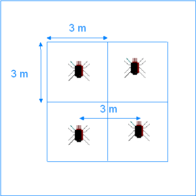
Tick index
The calculated distance between ticks in a given habitat,
assuming an equally distributed population.
In this diagram, the area per tick is 9 square meters,
therefore the tick index = 3.
Diagonal of a square > sum the
squares of 2 sides and derive the square root = diagonal
The
numbers are derived by collecting ticks at
roughly fortnightly intervals in three locations:
 15 Aug 2009
PRELIMINARY RESULTS: The results below indicate that the highest risk of
encountering ticks (where the lower numbers indicate the distance between ticks
on the ground) was:
| Ringmoor Down - 2009
|
June - this area is higher,
more exposed, therefore cooler and later developing? |
| Brisworthy bracken - 2009 |
April & May |
| Yarner - leaf litter - 2009
|
May & June |
|
Ringmoor Down - 2009 |
|
Date: |
Jan-20 |
Jan-28 |
Feb-20 |
Mar-18 |
Apr-6 |
Apr-20 |
21-May |
22-Jun |
20-Jul |
28-Jul |
25-Aug |
27-Aug |
10-Sep |
26-Sep |
13-Oct |
31-Oct |
23-Nov |
24-Nov |
16-Dec |
22-Dec |
|
Number of ticks: |
0 |
0 |
0 |
0 |
0 |
19 |
57 |
64 |
9 |
4 |
4 |
0 |
0 |
5 |
11 |
8 |
0 |
0 |
0 |
0 |
|
Drag length (m): |
--- |
--- |
860 |
930 |
1,000 |
1.000 |
1,000 |
1,000 |
1000 |
1000 |
1000 |
1000 |
-- |
1000 |
1000 |
1000 |
1000 |
1000 |
1000 |
1000 |
|
Area per tick (m²): |
--- |
--- |
0 |
0 |
0 |
52.6 |
17.5 |
15.6 |
111 |
250 |
250 |
0 |
-- |
250 |
91 |
125 |
--- |
--- |
--- |
--- |
|
Öarea =
index |
--- |
--- |
0 |
0 |
0 |
7.3 |
4.2 |
3.9 |
10.5 |
15.8 |
15.8 |
0 |
0 |
15.8 |
9.5 |
11.1 |
0 |
0 |
0 |
0 |
|
|
Brisworthy bracken - 2009 |
|
Date: |
Jan-20 |
Jan-28 |
Feb-20 |
Mar-18 |
Apr-6 |
Apr-20 |
21-May |
22-Jun |
20-Jul |
28-Jul |
25-Aug |
27-Aug |
10-Sep |
26-Sep |
13-Oct |
31-Oct |
23-Nov |
24-Nov |
16-Dec |
22-Dec |
|
Number of ticks: |
0 |
0 |
5 |
30 |
29 |
29 |
34 |
8 |
3 |
13 |
0 |
5 |
0 |
13 |
6 |
3 |
0 |
0 |
0 |
0 |
|
Drag length (m): |
--- |
--- |
861 |
648 |
686 |
500 |
513 |
500 |
753 |
501 |
500 |
500 |
-- |
500 |
500 |
500 |
500 |
500 |
500 |
1000 |
|
Area per tick (m²): |
--- |
--- |
172.2 |
21.6 |
23.6 |
17.2 |
15.1 |
62.5 |
251 |
38.5 |
0 |
100 |
-- |
38.5 |
83 |
166 |
--- |
--- |
--- |
--- |
|
Öarea =
index |
--- |
--- |
13.1 |
4.64 |
4.86 |
4.2 |
3.9 |
7.9 |
15.8 |
6.20 |
0 |
10 |
0 |
6.2 |
9.1 |
12.9 |
0 |
0 |
0 |
0 |
|
|
Yarner - leaf litter - 2009 |
|
Date |
20-Jan |
28-Jan |
15-Feb |
08-Mar |
22-Mar |
08-Apr |
21-Apr |
10-May |
29-May |
08-Jun |
27-Jun |
19-Jul |
25-Jul |
Aug |
27-Aug |
10-Sep |
26-Sep |
10-Oct |
28-Oct |
16-Nov |
24-Nov |
13-Dec |
27-Dec |
|
Ticks |
8 |
16 |
22 |
7 |
10 |
25 |
38 |
120 |
222 |
43 |
282 |
99 |
84 |
264 |
162 |
14 |
265 |
44 |
57 |
0 |
10 |
21 |
0 |
|
Tick population: |
24960 |
49920 |
68640 |
21840 |
31200 |
78000 |
118560 |
374400 |
692640 |
134160 |
879840 |
308880 |
262080 |
823680 |
505440 |
43680 |
826800 |
137280 |
177840 |
0 |
31200 |
65520 |
0 |
|
Area |
56 |
28 |
20 |
64 |
45 |
18 |
12 |
4 |
1.1 |
10.5 |
1.6 |
4.5 |
5.4 |
1.7 |
2.8 |
32.3 |
1.7 |
10.2 |
7.9 |
0 |
45.2 |
21.5 |
0 |
|
Length = Index |
7.5 |
5.3 |
4.5 |
8.0 |
6.7 |
4.2 |
3.4 |
1.9 |
1.0 |
3.2 |
1.2 |
2.1 |
2.3 |
1.3 |
1.6 |
5.6 |
1.3 |
3.2 |
2.8 |
0 |
6.7 |
4.6 |
0 |
|
Temp. |
6 |
11 |
10 |
7 |
16 |
14 |
18°C |
16°C |
21°C |
16°C |
24°C |
17°C |
19°C |
19°C |
18°C |
20°C |
16°C |
16°C |
16°C |
14°C |
11°C |
7°C |
7°C |
Variation in summer numbers - due
to the no. of larvae and the vagaries of hatchings?
The following survey was abandoned on 27
June for safety reasons .............
|
Yarner - undergrowth - 2009 |
|
Date: |
Jan-20 |
Jan-28 |
Feb-15 |
Mar-22 |
Apr-8 |
Apr-21 |
May-10 |
May-29 |
Jun-8
Wet |
Jun-27 |
Oct |
Nov |
Dec |
|
Number of ticks: |
- |
- |
- |
23 |
15 |
20 |
14 |
-- |
1 |
0 |
0 |
0 |
0 |
|
Drag length (m): |
- |
- |
- |
341 |
341 |
341 |
341 |
-- |
341 |
|
|
|
|
|
Tick population: |
- |
- |
- |
94,783 |
61,815 |
84,240 |
57,694 |
-- |
4,121 |
0 |
0 |
0 |
0 |
|
Area per tick (m²): |
- |
- |
- |
15 |
23 |
17 |
17 |
-- |
341 |
|
|
|
|
|
Öarea =
index |
- |
- |
- |
3.9 |
4.8 |
4.1 |
4.1 |
-- |
18.4 |
|
|
|
|
|
Some explanation of the
Yarner Wood calculations .....
-
Yarner Wood, using MemoryMap, is 140.44 hectares = 1,404,400 sq. meters. Dividing this area by the
swept area (452 sq. meters) gives a factor of 3120 (no allowance is made for
hard surfaces such as the road into the wood, car park, tracks, buildings, trees
cumulative cross-sectional area and water). This factor is used to calculate
the total tick population at the collection date.
-
Initially, only the ground was
sampled because of the problems in trying to drag the undergrowth and the fact
that it was impossible to keep the blanket "flat", so the area covered would
actually be highly questionable. Also, there were no ticks on two occasions when this
was tried in the winter.
-
However, on 22nd March, a
355-meter drag through the undergrowth produced 23 ticks (mainly nymphs but also
males and females). This was more than the number found on the ground.
-
It may be that the fall in tick
numbers on 8th March may reflect the fact that the ticks were then climbing up the
vegetation?
-
Henceforth, it seems that both
areas should be sampled.
-
On May 10th there was a huge
disparity between the tick numbers for the ground cover and the taller
vegetation. A large number of larvae were collected from the ground sweep,
probably a new "hatching" period(?), in fact there were so many that removing
them from the blanket was abandoned and I stopped counting after locating 30
still on the blanket - they were left there to be dealt with by very hot washing,
even simmering in an old preserving pan.
-
On June 27th the undergrowth
"drag" was abandoned because of the shoulder height bracken (being awkward to
drag over) and the very high numbers of larvae in the area - the risk of
personal exposure was finally considered to be too great.
NB -
THIS CHART NEEDS UPDATING ......
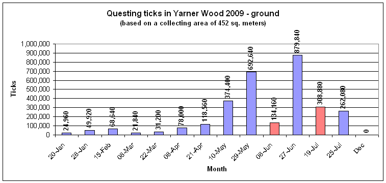
Red datum points indicate
damp/wet collecting conditions and may be replaced by later dry day results
While the figures above are for
"questing" ticks, there are probably more that are not questing and these are
not represented in these figures, which are therefore an underestimate of the
population.
"Tick
index" - I am sure someone must have proposed this idea in ecology a long
time ago, I know there are books about mathematical ecology. There's
little new under the sun!
Addition to "Tick index"-
Actually, this is more correctly called "population density" but I like the
idea of citing a distance between ticks so that non-scientific types can have an
easily understood idea of tick density in a habitat. Of course, the concept of
square area between ticks is a simplification, they could be circular patches,
with complications in describing a distance, or a figure may be given with
square areas to describe the diagonal separation between individuals.
More scientific descriptions in
the field can be found here:
Viewers could also put "population density"
into an internet search engine and spend a while deciding for themselves which
they prefer .....
All tick visitors counted by
StatCounter